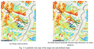
The recent increase in earthquakes in Korea, including those in Kyeong-Ju and Pohang, has caused significant damage and landslides in surrounding areas. This study investigated earthquake-induced landslides to identify ways to reduce the risk of damage caused by slope instability. Landslide risk was assessed through finite element analysis of the slope factor of safety using topographic and geological data of the Pohang region combined with actual earthquake observations. A path was established to evaluate the slope stability and hazards at the end of the slope. The results of this study were compared with the landslide hazard map and showed good agreement, validating the accuracy of the model. In addition, the analysis of different paths provided quantitative and precise information about slope boundaries. Landslide hazards increase under earthquake conditions. Obtaining a quantitative factor of safety provides valuable information for designing slopes and adjacent areas.